This illustrated map of Brussels was long overdue, which I’m really happy to showcase to you guys!
After coming back from a cracking visit to Brussels last November, where I exhibited my work at NATO Charity Bazaar, which was a fantastic event that gave me the honourable opportunity to sell my art prints, canvas paintings and greetings card to the public, I also had a good look around Brussels itself.
I was amazed by the architecture and natural beauty of the place, especially the Grand Place and the strange but very popular attraction of ‘Manneken Pis’. Even though it’s a large City, it’s relaxed, chilled out, and not too hectic, which I really enjoyed about the place.
As I have a keen interest in map illustrations and depicting cities all across the globe, which I’ve done on several occasions, (including my illustrated map for the Odiham Society, which is close to where I currently live), this personal illustrated map was inspired by the trip from last November.
Incorporating popular landmarks like ‘Royal Palace’, ‘Saint Gudule’, ‘Bourse’ to ‘Saint Catherine’, this illustrated map was w a joy to paint and depict, which I had a lot of fun with!
Let me know what you think of this illustrated map of Brussels, I’ll love to hear your comments below!
Thanks, and enjoy the illustration!
Many thanks for listening and visiting my news page today. You can follow what I’m up to on my Twitter, Facebook or Google + pages, I’ll really appreciate it if you do, and don’t be afraid to say hi to me! Many thanks again, and have a great day!


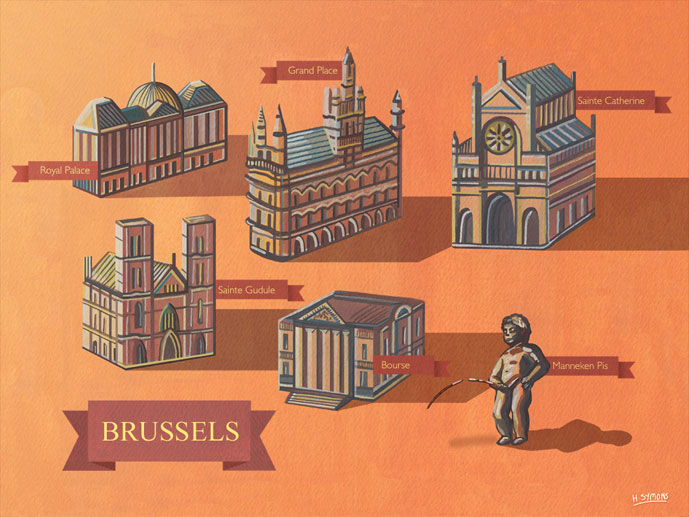
Illustrated Map Of Brussels
 1st May 2015